SE0640 : Footpath to Thwaites Brow (4)
taken 6 years ago, near to Keighley, Bradford, England
This is 1 of 4 images, with title starting with Footpath to Thwaites Brow in this square
Footpath to Thwaites Brow (4)
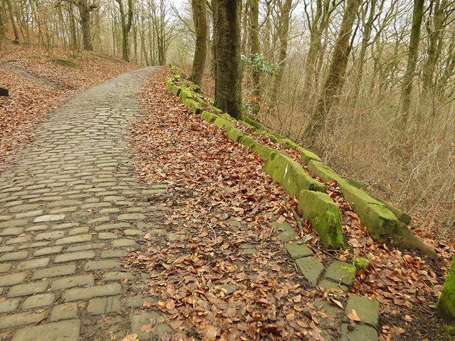
A splendid example of a stone-setted footpath from the days of the Industrial Revolution, which appears on maps as early as 1852. I presume it was for workers to reach the factories in the town of Keighley (and at another time maybe for quarry workers living in the valley bottom to reach the quarries higher up the hill).
This view in Park Wood shows how the path has tended to slip down the hillside, despite repeated attempts to stop it with stone flags.
This view in Park Wood shows how the path has tended to slip down the hillside, despite repeated attempts to stop it with stone flags.
![Creative Commons Licence [Some Rights Reserved]](https://s1.geograph.org.uk/img/somerights20.gif)
|
· Find out How to reuse this image ·
Share:
|
|||||
| Start a discussion on SE0640 | Suggest an update to this image | Contact the contributor | |||
 Map © Crown Copyright")
TIP: Click the map for more Large scale mapping
- Grid Square
- SE0640, 231 images (more nearby
 )
)
- Photographer
- Stephen Craven (find more nearby)
- Date Taken
- Saturday, 13 January, 2018 (more nearby)
- Submitted
- Tuesday, 16 January, 2018
- Geographical Context
- Subject Location
-
OSGB36:
 SE 0696 4092 [10m precision]
WGS84: 53:51.8671N 1:53.7391W - Camera Location
-
OSGB36: SE 0697 4092
- View Direction
- WEST (about 270 degrees)
Looking for a postcode? Try this page
Other Tags
This page has been viewed about 33 times.
View this location:
KML (Google Earth) ·
Google Maps ·
Bing Maps ·
Geograph Coverage Map ·
More Links for this image